A geostationary satellite is positioned at a distance of how many kilometres above mean sea level?
Options
A35,880
B37,800
C35,786
D32,000
Show AnswerHide Answer
Correct Answer
C35,786
Model Answer
Geostationary Satellite
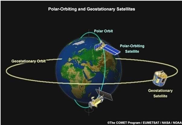
Geostationary orbit - The circular geosynchronous orbit in the plane of Earth's equator, 35,786 kilometers (22,236 miles) above Earth's equator is known as geostationary orbit. The radius of the orbit is approximately 42,164 km.
A satellite revolving in such an orbit is called a geostationary satellite.
It follows the direction of the Earth's rotation i.e. west to east and the orbital period of such satellites is equal to that of Earth's rotation (roughly 24 hrs).
It thus appears motionless relative to Earth, and hence the name geostationary satellite.
The Syncom 3 was the first geostationary satellite launched by a Delta D rocket in the year 1964. It transmitted live coverage of the Summer Olympics from Japan to America.
Benefits of Geostationary Satellite
These satellites find immense use in communication as they do not require ground stations to have movable antennas and these can also be used to improve the navigation attributes (like accuracy, reliability, availability, etc.) of a Global Navigation Satellite System (GNSS).
These satellites also find their use in meteorology as they are used to provide visible and infrared images of Earth's surface and atmosphere for weather observation, atmospheric tracking, and oceanography.
The first geosynchronous satellite launched in 1963 was able to relay TV transmissions and the US President John F Kennedy was able to telephone the Nigerian Prime Minister Abubakar Tafawa Balewa from a ship on August 23, 1963.
Diagram of a polar-orbiting satellite on a polar orbit and a geostationary satellite on the geostationary orbit around the Earth.